Tag Archives: sediment transport

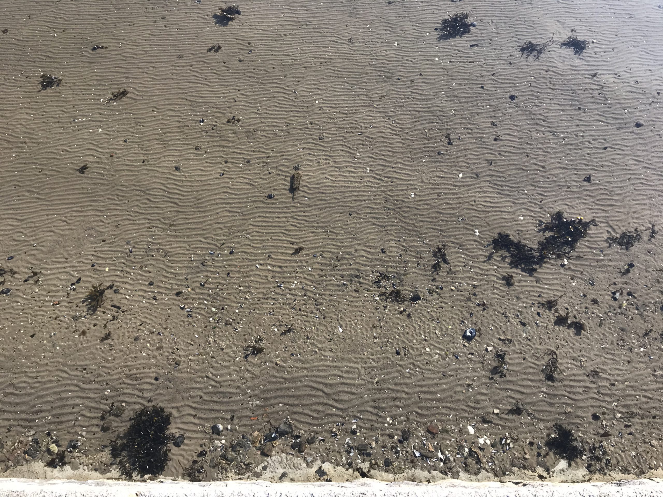
Irregular wave ripples, and some left on the beach when the water is gone

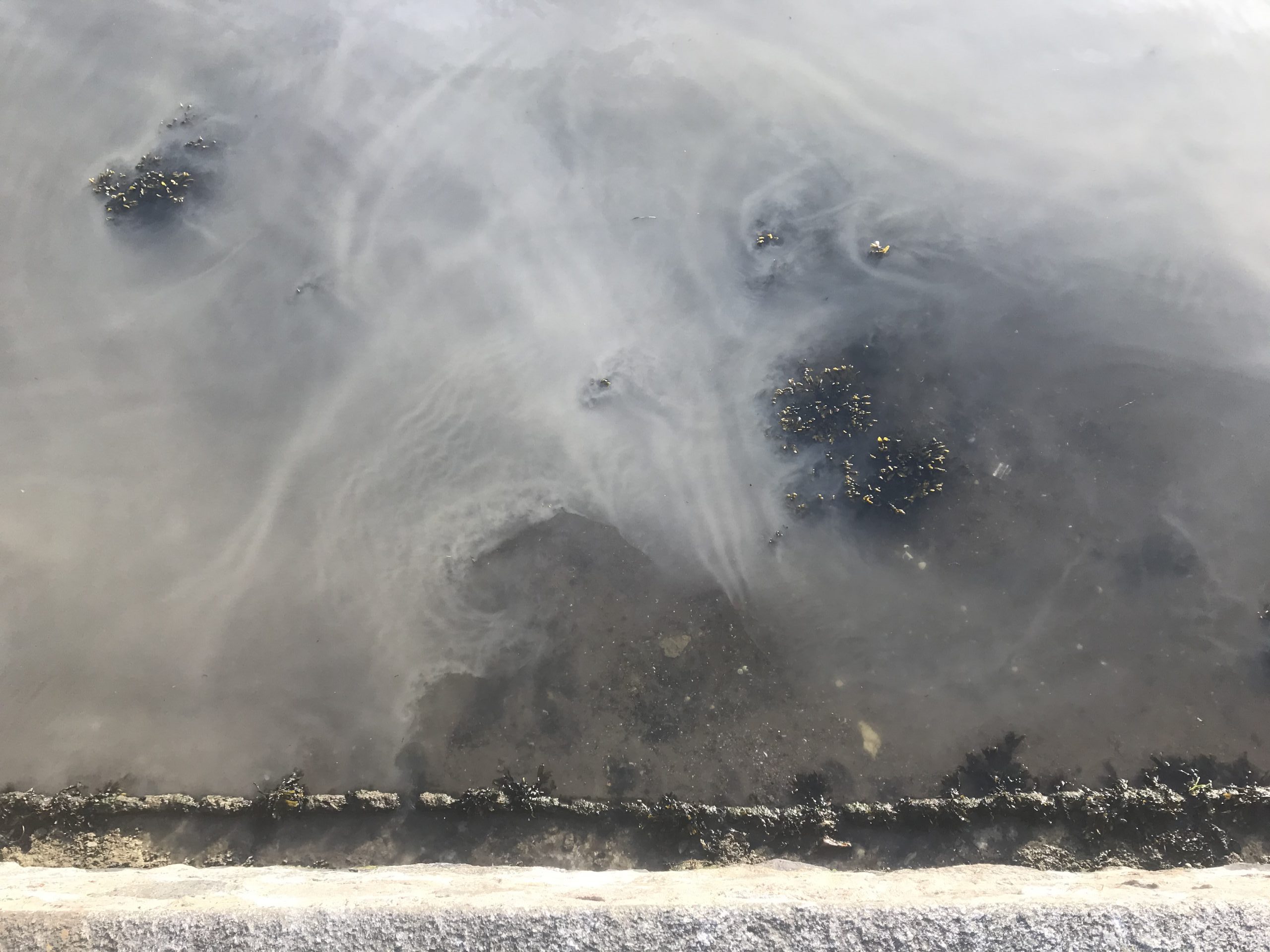
I’m getting more and more fascinated with wave ripples. I kinda understand how they form, but not enough to be able to explain as much about them as I would like to.

For example below: Why is the pattern so different where sand has been washed on top of the shallow stones? Yes, the water depth is different there, which will have an influence on the wave field, which will, in turn, have an influence on sediment transport. But HOW?

Here is another example. The wave ripples look choppy everywhere (and kinda cool!), but on that shallow, flat surface of the stone the wave length is completely different as is the orientation. And this is still all submerged, you can kinda estimate the water depth from the tips of the kelp stuff just reaching the surface.

Same day, slightly different area. Isn’t it cool to see how in the upper left there are no wave ripples but those streaks of larger pebbles?

And look at this. Utter chaos in the middle, little more orderly ripples to the sides! Why???

Or here. Steep wave ripple crests, long and shallow troughs in which larger stuff has been deposited (or is it the finer grain that has been transported away from the troughts into the crests and the coarser stuff got washed free and just stayed?). Estimates of water depth with help of kelp tips just breaking the water surface again…

Different day, more orderly wave ripples. But wavelength changes with distance from the sea wall. And weird things happen on the shallow stones…

On a low water day, parts of the sea floor got exposed. Now. I know for sure there were ripples all the way to the seawall. But at some point, the water retreated. When did they get smoothed out? The problem is that I can only really observe the seafloor when the water is calm, yet ripple marks form when there are waves. What happens during the transitional period? Or here, when the water level sinks?

Another interesting pics with some ripple marks that are still there, and then these little, smooth spots that recently fell dry (within maybe 15 minutes or so — I took pictures that same morning when there was still water on top and you could only see that there was a bump under the surface by “reading the wave field”. And then when I came back, the water level had fallen and this piece of mud had been exposed). Did the ripples there get smoothed out when there was still water on top, or at what point did it happen?

Or here where we have these interesting rip-current like structures right at the bottom of the sea wall:

Here is another thing I find fascinating: Ripples towards the sea wall, and then these streaks of larger stuff probably aligned with the main direction of the waves (I think the larger stuff is less dense than the sand, though, maybe pieces of broken shells?). What has to happen in order to transition between these two regimes?

Also note how there is no sand on the large flat stones today!

And same spot, different day: More ripples gone, and even less sand on the large flat stones!

So how do I figure out what is really going on here? I guess I would need to capture both the wave field and the sea floor over time. Web cams above & below water level, plus measure water depth? Any suggestions?

Foam stripes and sand ripples

So you might have seen my novel on the formation of sand ripples last week, and the tl;dr: I have a vague idea of how sand ripples form, but it’s not as clear to me as I would like.

But imagine my delight when, after two days of foam stripes like this one…

…there was a distinctly different ripple pattern directly underneath the foam stripe!!!

In some places, there was even a tiny little bit of foam left. Where? Right on top the anomalous stripe in the ripple pattern!!!

So now I still don’t understand what’s going on in the sand, but at least it’s lining up exactly with a phenomenon in the waves that I don’t understand, either! :-D

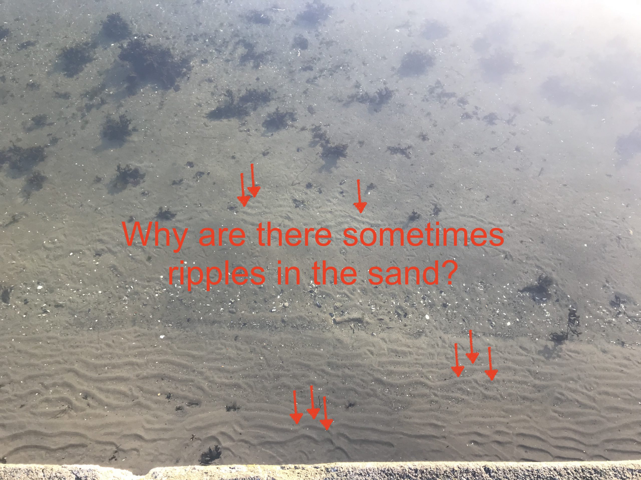
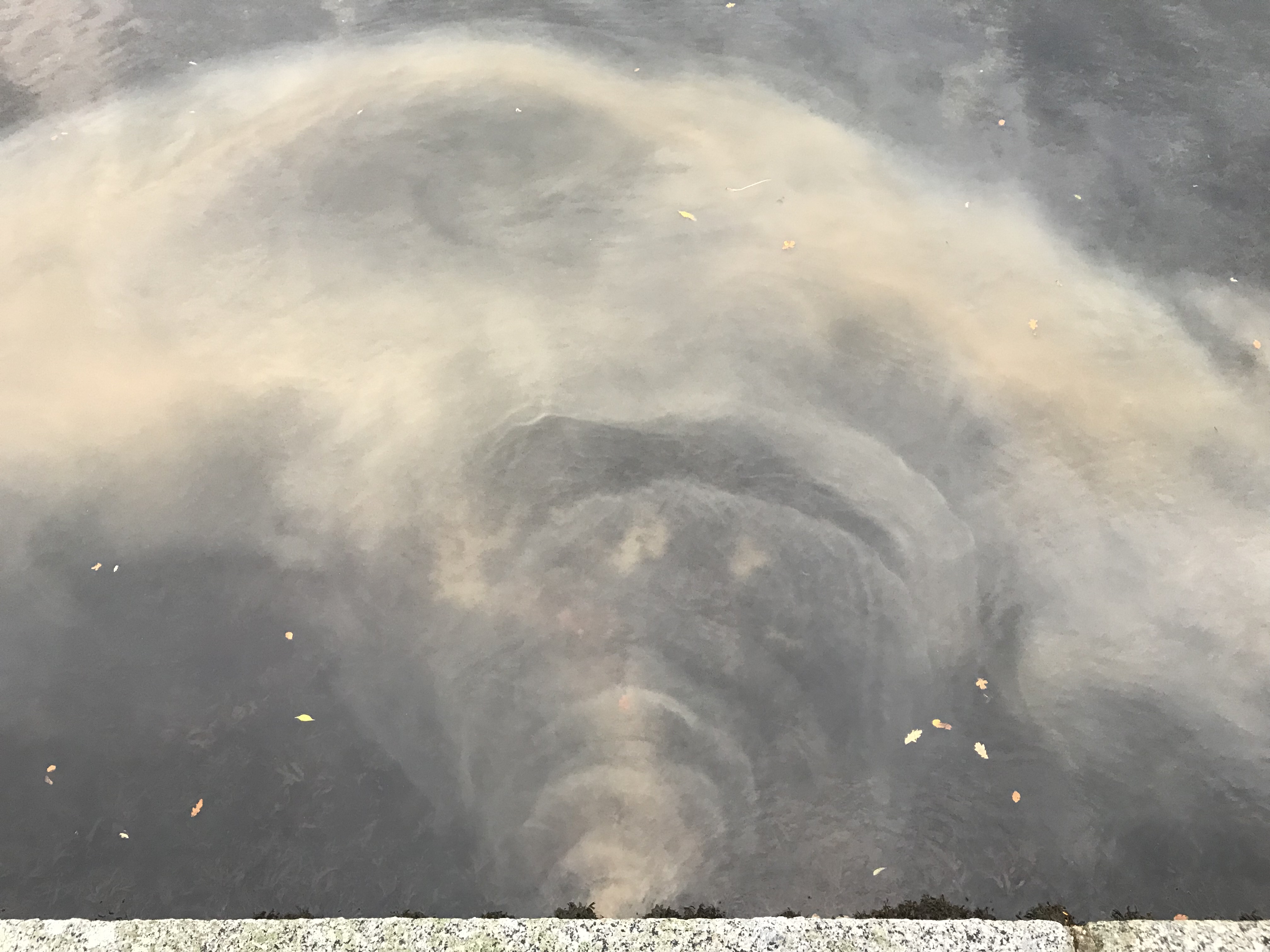
Sand ripples. Why do they form in the exact way they do?

It has been bugging me for a while that on days where there isn’t a lot going on in terms of regular wave watching, I often see ripples in the sand and don’t understand what’s determining their wavelength, their shape, everything about them. So what better use of a quarantine weekend than to browse old pics, and do a literature search to try and figure out what’s going on?

There surely is a “wave ripple 101” textbook out there somewhere, but I didn’t find it (even though I know fossilized wave ripples are sometimes used to draw conclusions about prehistoric wave regimes and stuff, so there MUST be textbooks on this? What search term am I missing?), so I had to make sense of the information I did find. If you know better or know where to find better information, please let me know!

How sand ripples form in a current

Basically like waves form in water, except without the help of surface tension.

When water is moving relative to a sandy bottom, there is a critical speed at which sand grains are going to start moving with the current. Currents faster than that speed are going to erode the sea floor, taking sand with it, currents slower will allow sand to fall out of the current and settle.

Imagine a current over a sandy bottom. If the bottom isn’t completely flat but there is a tiny imperfection somewhere, this will influence the bottom current: speeding it up the higher the bump is (i.e. the smaller the cross section of the current becomes) and slowing it down when the cross section widens again (see here for the classical fluid dynamics Venturi tube experiment that shows exactly that). So a current flowing over a bump will be sped up. Looking closely at the bump, it has an asymmetric profile: A gradual incline on the upstream side (apparently called the “stoss side”) and a steep drop on the lee side. Sand is being eroded from the upstream side where the current is strong, and being deposited on the lee side where the current is weak, thus slowly moving the bump forward.

In slower currents, sand grains are being rolled up the upstream slope of the ripple, are pushed over the edge and tumble down on the other side. In faster currents, an eddy is going to form downstream of the bump, similar to a lee water in a river, and grains are “flying” over this eddy and deposit on the stoss side of the next ripple.

How sand ripples form in waves

In the end, waves in shallow water (and they have to be in shallow water for the sea floor to feel their influence in the first place) are nothing else than alternating currents as the orbital movement within the waves is deformed into elipses with a back-and-forth current right at the bottom. So ripples in waves form in a similar way to ripples in currents, except that they are more symmetric and (probably?) don’t propagate.

What determines sand ripples’ wave length

I think this is what has been bugging me most for a long time, because I was trying to figure out some kind of dependency on wave length of the water waves or something, but now I think it’s actually quite simple (Please check out the disclaimer above…): I think it’s a mixture of grain size and current speed.

The influence of current speed

The faster the current, the longer the wavelength of the ripple. This makes sense since in stronger currents, grains are transported further away from the ripple they were erodet from until they deposit again and form the next ripple.

Stronger currents are probably linked to longer waves (with larger orbitals) and shallower water.

The influence of grain size

If sand grains are too small, they don’t form ripples (or they are just extremely flat). However, if the grains are more like stones, they are not moved into ripples anymore, either, but instead create a turbulent flow around them. But for the happy medium in between, I think the larger the grain, the larger the ripple (both in length and in amplitude).

Of course, it’s not only grain size, it’s also tons of other factors like grain shape (that will influence cohesion between grains) or bio growth like bacterial mats, that will also make it more difficult for grains to be moved.

Finally! Looking at ripples

Note: All pictures of wave ripples I am showing here were taken in Kiel fjord, looking down from the sea wall into the water. There is usually a bit of the sea wall still visible for orientation, and further away from the sea wall the sky reflects on the surface. This is not ideal, but it’s all I have to work with right now.

Let’s check out the picture below: Here we see quite regular wave ripples, except very close to the sea wall (where the sand appears flat, possibly because the water is very shallow there), and close to kelp (where the sand is flat, too, but probably due to wave-plant interactions; i.e. either the plant taking energy out of the wave field and dampening the wave, or the plant being moved over the sand by the waves, thus wiping out any ripples that might have been there).

More fairly regular ripples.

Sometimes ripples are a lot less regular and look a lot more choppy. Not surprising seeing that often waves get reflected at the sea wall at an angle, creating a checkerboard pattern of wave crests, thus not only a back-and-forth orbital flow, but probably more of a circular one. But why is there still a predominant direction of wave crests then? Does anyone know?

Below you see what I mean: In the upper corners of the picture you see the water wave crests at an angle to each other.

The picture below I find really beautiful with this nice wavy pattern.

And here, we see very different structures in different spots — some more regular, some very choppy.

And there is a lot going on in the picture below. We see an effect of grain size with coarser grains not showing many ripples and the fine mud not showing any, either. But that might also be due to algae mats protecting the mud from erosion?

Below we see a similar thing again. I think the longer wavelengths closer to the sea wall are due to the shallower water depth there (hence more energy and higher velocities in the waves’ orbitals), then a slightly deeper part, then a corser-grained part and then mud covered in algae.

Here is another nice example of what I call “choppy ripples” — a lot choppier closer to the small and large stones at the sea wall than further offshore, and then a smooth bottom even further out. I haven’t quite figured out why the small stones there align perpendicularly to the sea wall. Any ideas, anyone? I’ve seen that so much on beaches, it must be quite obvious!

Oh, and here is a nice example of an obstacle influencing ripples. I like how they bend around the edge if that stone step! And also again very clearly different regimes related to different grain sizes and water depths.

And again…

Here is another picture where algae mats seem to inhibit ripple formation.

And here is an example of that phenomenon I talked about earlier that I haven’t really figured out: When there are no ripples, we often see debris in rows perpendicular to the sea wall. Why???

One thing I find very cool is when there are large, flat stones on the seafloor and they get partly covered in sand that forms ripples. I just think it looks super pretty!

Another one of those:

And here some very choppy ripples!

Here the ripples become more regular the further away from the seawall we look.

And now this one, if the light wasn’t so horrible, I would print and frame and put on my wall!

If you have made it all the way to the end of this post, tell me: Aren’t these ripples in the sand almost as fascinating as actual waves? And do you understand what’s going on there?

Broken water pipes

So yesterday this happened: When I was on my way to meet my friend for a run early in the morning, the whole pavement was flooded (look at the cute little hydraulic jumps!). After calling the authorities (and judging from the telephone operator’s voice, I wasn’t the first one! But then how should I know at 6 in the morning when there is nobody else around?) I took a couple of pictures.

There was a lot of water, some of which the storm drains managed to catch.

Luckily, I know where the storm drains lead to — via a little stream and a little lake — right into Kiel fjord!

Below, we are looking down from the sea wall into the fjord. Towards the right, you see the turbulent outflow from the storm drain into the fjord. And then on the left you see curtains of where the mud concentrations change! That’s what I was hunting for when I went down to the water — spots in which the muddy water could be used as flow tracer!

When we walk a bit further to the left, similar curtain pattern are still clearly visible, as well as turbulence behind that rock.

And even more clearly in the picture below: Interesting how there are pockets of clear water are persisting in the muddy waters, isn’t it? Even though the plume of muddy water is spreading, and is being slushed back and forward with the waves on Kiel fjord.

And this is the outer edge of the plume. I love how we can still see that the plume’s mud concentrations varied over time, with the water that came first being pushed furthest out from where the water enters Kiel fjord, and then newer water forming layers inside it.

Sorry about the weird lighting in the picture below, but you see well the record of mud concentrations in the plume:

Even cooler when you go to the other side of the plume: here the plume interacts with rocks and algae to form mud wakes!

I don’t think I’ve fully figured out why they look the way they look, or in general, why the plume is looking so different on this side. Any ideas?

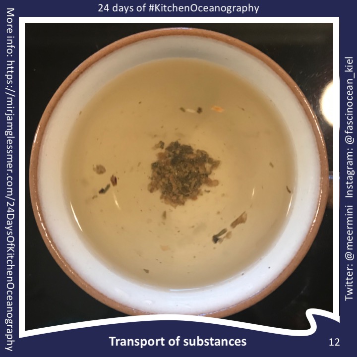
Watch how sediment is transported with the flow while surface waves above move in the same direction but much faster

When I was on my way down to Kiel fjord earlier this day I was in a bit of a weird mood. I was thinking about how the weather was grey and gloomy. And how that meant that there wouldn’t even be a nice sun raise to take pictures of. And how I might already have said everything there is to say about waves in that area of Kiel fjord.

But then, this happened.

Thanks to people working on the drainage system on the other side of the road, there was a lot of sediment dissolved in the water dripping into Kiel fjord! And watch how it spreads into half circles from where it enters the fjord. How pretty is that?

And then, even better, when you look at the surface waves, they propagate a lot faster than those clouds of sediment do. So this is a really nice example of how wave motion and transport of matter in the ocean are independent of each other (as a first order approximation at least).

We do see an influence of waves on the sediment rings further out as they get deformed by the wind waves on Kiel fjord.

Actually, looking at the whole thing from a bit further away and not from directly above, we see that the sediment forms a plume parallel to the coast rather than spreading out in half circles further. And this I do believe is due to wave action. But let’s focus on the area right around the outflow… ;-)

I found this pretty cool to watch and was very glad I stopped my run to take pictures and movies when I first saw it, because on my way back it was all gone already. Lesson learned: Always stop to observe the cool stuff instead of pushing through with the exercises you planned on doing ;-)