No, the edge of our tank is not “the equator”
A very common idea of what goes on in our tank is that we have a tiny Antarctica in the center and that the edge of our tank then represents the equator. We are rotating in Southern Hemisphere direction, clockwise when looked from above the pole. And when looking at the Earth that way, where the Earth seems to end is at the equator. It makes sense to intuitively assume that the edge of the tank then also represents “the end of the world”, i.e. the equator.
But then it is confusing that our Antarctica is so big relative to a whole hemisphere and that we don’t have any other continents in our tank. And it’s confusing because the idea that the edge of our tank represents the equator is actually wrong.
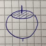
In our tank, however, we don’t have a changing latitude, it’s constant everywhere. You can imagine it a little like sketched below: As if the top of the Earth was cut off at any latitude we chose, and then we just put our tank on the new flat surface on top of the Earth: the latitude is constant everywhere (at least everywhere on the shaded surface where we are putting our tank)!
Since the latitude is constant throughout our tank, so is the Coriolis parameter. That means that if we want to simulate Antarctica, we will match our f to match the real Antarctica’s, except scaled to match our tank. And if we wanted to simulate the Mediterranean*, we would match our f to the one corresponding the Mediterranean’s latitude.
This means that we actually cannot simulate anything in our tank that requires a change in f, much less half the Earth! So currently no equator in our tank (although that would be so much easier: No need to rotate anything since f=0 there! :-)
—
*which, in contrast to my sketch above, is well in the Northern Hemisphere and not at the equator, but I am currently sitting at Lisbon Airport and this sketch is the best I can do right now… Hope you appreciate the dedication to blogging ;-)


Throwback to the pandemic and teaching from home: "An ocean in a bucket" - Adventures in Oceanography and Teaching says:
[…] misconception we are addressing is that in a rotating tank experiment, the centre of the tank represents a pole and the edge of the tank represents the equator. This is a very common misconception, especially in cylindrical tanks, and it is also easily […]