Tag Archives: breaking waves

One of the most difficult #friendlywaves I’ve ever gotten! Did I get it right?

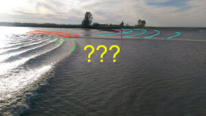
Florian sent me a #friendlywave — a wave picture he took, with hopes that I might be able to explain what is going on there. And this one had me puzzled for some time!

This is what the picture looks like:

What I knew about it: Florian was on the ferry from Wisschafen to Glückstadt, crossing the Elbe river.

In the picture itself, there are several features that jumped at me. First, drawn in with the lightblue line below: A sand bank parallel(-ish) to the island’s coast line.

Then, the ship’s wake (shown in red) breaking right near the ship (orange) and turning (green) and breaking (yellow) where it runs on the sand bank.

Florian wrote he was watching the ferry’s wake and noticed something curious: There seemed to be a shallow part, where the waves suddenly became a lot faster! And could I explain what was going on?

Looking at the picture, there were two possibilities for what he might have meant (and, spoiler alert — I completely jumped on the wrong one first!).

Below, I’ve drawn in the part of the wake that is running on the shallow sand bank (green) and how those wave crests continue on the other side of the sand bank (red). I’ve also drawn in some mystery wave crests in blue. Those were the ones I chose to focus on first, since Florian had written that he noticed waves behaving weirdly and suddenly becoming much faster. So if we are talking fast, we are talking really fast, right?

So how do we explain those blue wave crests?

There is a limit for the maximum speed a wave can have. That limit depends on the wave’s wave length: The longer a wave, the faster it travels. In deep water, i.e. water deeper than 1/2 the wavelength, the wave travels at this maximum speed (see green lines in the plot below).

But as it comes into shallower water, it gets slowed down (see black lines in the plot below — those are just a quick sketch, there are complicated equations to calculate it exactly).

In shallow water, i.e. water that is smaller than 1/20th of the wave length, the phase speed only depends on water depth: The shallower the water, the more the wave is being slowed down (see the red lines in the plot below).

Sorry about the quality of the sketch — I don’t have Matlab or anything else useful on the computer I have available right now, so I drew this in ppt! Take it with a pinch of salt, but qualitatively it’s correct!

So looking back at Florian’s picture, for the blue waves to have been caused by Florian’s ferry, there are two options:

A) they would have to have wave speeds faster than the ferry’s bow wave and wake

B) the ferry would have had to come from the direction of the island, so that the waves propagated in that deeper channel behind the sand bank before the ferry made its way around the sandbank.

Option A is impossible, because wakes travel at maximum wave speed (similar to a sonic boom in the atmosphere, where sound is travelling at maximum speed, forming a cone with the air plane at its tip, only here it’s a 2D version, a V-shaped wake with the ship at its tip). So if the wake is traveling at maximum speed already, then the blue waves can’t go faster than that.

For option B, looking Florian’s ferry up on a map, I saw that that ferry goes around a small island, which is the land you see in his picture. But a quick glance at the map shows that even though the sand bank seems to end where the ship would have had to have gone in order to create those waves, the island is still very much in the way. So this can’t be the solution, either.

This map is published at http://map.openseamap.org under a CC BY-SA 2.0 license

So let’s take another good look at the original picture.

Remember those wave crests that I marked in blue? Well, upon closer inspection it turns out that they are tidal gullys and not wave crests! (Which is what Florian confirmed when I asked whether he remembered the situation) Guess I have been barking up the wrong tree all this time!

So back to the wave crests that I marked in red:

What we see here is exactly the depth dependence of the phase speed that I plotted above. Right at the sand bank, the water is shallowest and waves are slowed down (we see that both in the green wave crests that seem to be falling back and start breaking as they get closer to the sand bank [both indicating that the water is getting shallower], and in the red wave crests right at the sand bank). But as the water gets deeper again on the far side of the sand bank (which depth measurements in the map above seem to confirm), the phase speed picks up again (as it has to — see my plot above) and the wave crests accelerate again. Hence we have the weird phenomenon of waves suddenly speeding up!

Very long explanation, I know, but still pretty cool now that we solved it, right? I love #friendlywaves — if you have any mystery wave pictures, please do send them my way! :-)

Such a pretty #friendlywaves!

My long time Twitter friend Anne shared these beautiful pictures and I absolutely had to do a #friendlywaves post where I explain other people’s wave pictures.

Take a moment to admire the beautiful picture below. Wouldn’t you love to be there? I certainly would!

What can we learn from this picture? First — it’s a windy day! Not stormy, but definitely not calm, either. See how the water outside of the surf zone is dark blue and looks a little choppy? That’s the local wind doing that.

And then there are the waves that we see breaking in the foreground. Without knowing where the picture was taken, I would think that they traveled in from a large water body where there was a long fetch so they could built up over quite some distance. And then they meet the coast!

You see breaking waves of two kinds: the one marked with red ovals below, where there is hardly any buildup of the wave before it meets a rock and breaks into white, foamy turbulence. The other type of breaking waves, the ones where I marked the crests with green lines, build up over a short distance before they break because there is a more gradual decrease in water depth. The stope is still quite steep so the waves change from deep water (where they can’t feel the sea floor and have a fairly low amplitude, so we can’t distinguish wave crests further offshore than the two I marked in green) to shallow water waves that feel the sea floor and build up to break.

In contrast, let’s look at the lovely picture below.

Here, we have a sandy beach on which the waves can run out. There slope right at the water’s edge is not very steep, but seeing that we can only really spot two wave crests there has to be a change in gradient. About where the offshore wave crest is in the picture below, or possibly a little further offshore, the water depth must suddenly increase, otherwise there would be more wave crest visible further offshore. Since there aren’t any, water must be a lot deeper there.

But what I found really cool about the picture above are the trains of standing waves in the little stream that flows into the sea here. I find it so fascinating to see standing waves break in the upstream direction — so completely unintuitive, isn’t it? So much so that I dug out some pics from January for you and posted them last Friday in preparation for today’s post. Sometimes I actually plan my posts, believe it or not!

Standing waves don’t move in space because the flow of the current they are sitting on is exactly as fast as they are moving, only in the opposite direction. What is happening in the picture is that in those standing waves sit on ripples in the sand. The waves become so steep that they are constantly falling back down onto the current, get carried up the ripples again, in an endless loop. So fascinating!

A beautiful #friendlywaves from Spain

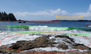
A reader of my blog, Rocío*, sent me this beautiful image from Arnao beach (Castrillón- Asturias-Spain), and I asked if I could use it in a #friendlywaves post. He agreed, so here we go!

First, let’s check out the original image in all its beauty, before I start scribbling on it. What features of the waves stand out to you that you find especially interesting?

For me, what I think is especially awesome here, is how the behaviour of the waves lets you draw conclusions about the sea floor underneath. Look at all the wave crests coming in nice and parallel. Far offshore, it’s difficult to even see wave crests (marked orange, for example), only when they come closer to the shore and the sea gets shallower, they start to build up, get a distinct shape. Yet in some places they become a lot steeper and start breaking a lot further offshore (red marks) than in others — why?

Because in those spots the sea is shallower, thus the interaction with the seafloor is a lot stronger. If you look at the yellow mark, for example: Offshore of it the wave crests are still very shallow and not pointy, and then all of the sudden they break. Here the water is deep until there is a very fast change and then it’s suddenly very shallow (and probably rocky, hence all the turbulence).

And then, if you come closer towards the shore, there is an area that has only a very gradual incline, where the shape of the waves hardly changes any more (blue marks).

And then there is a small inlet to a large puddle that acts as “slit” (albeit a fairly wide one) and lets waves radiate as half circles from where they enter through the slit.

I love how in such a beautiful image of such a beautiful landscape, there is so much physics that we can discover if we only choose to look! :-)

*I asked how I could credit the picture to Rocío, but he doesn’t have Twitter or a website and wrote “I only want you to explain it for people i love your blog and your information you are doing a great job”. Aaaaw, thank you!!! :-) And thanks for sending me this beautiful picture!

A #friendlywaves from Cyprus

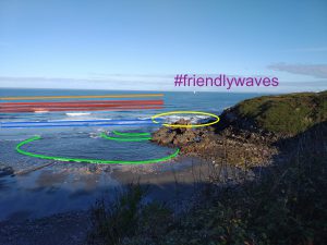
My friend Alice (of the awesome Instagram @scied_alice and the equally awesome blog, which you should totally follow) sent me a #friendlywaves from her trip to Cyprus. She said that this was a simple one, so I am looking forward to what else she has up her sleeve once I pass this test ;-)

So here we go with the pictures she send.

Clearly, she is on a boat trip, and she’s looking back at the wake of the ship. You see the one side of the feathery V of the wake, pretty much in the middle of the picture. On the “feather” closest to us, you can still make out the turbulent part of the breaking bow wave, where the water surface looks all crumpled up and not as smooth as it does further away from the ship. Actually, this is a really nice example to show that the waves are traveling away in the wake, but the water is not: All the other “feathers” further away have smooth surfaces as they have run away from the ship’s trajectory, while the turbulent wake traces out the exact path where the ship went (as long as there aren’t any currents moving around the water, which we’ll assume for now).

Picture by Alice Langhans, used with permission

The waves in the V-shaped wake are fairly steep, you can see them very slightly tipping over on occasion.

And Alice sent a second picture: Similar situation, except now it’s a little more windy. The turbulent wake is a little more foam-y than in the previous picture. This could be because the ship is sailing faster, or because it’s more windy. I would guess the first.

And when I say “sailing”, I am using this as the technical term for a ship driving. I am assuming that the boat Alice is on is not a sailboat. I’m thinking this because the wake looks fairly turbulent and sail boats usually don’t cause this much turbulence; also the little bit of the boat that I can see doesn’t really scream sailboat to me. We’ll have to wait to hear what she tells us, though!

Picture by Alice Langhans, used with permission

On both pictures, there is hardly any swell visible. Waves are usually not as visible when the water is deep as when they run up on a beach, and so far off shore we can assume that the water is fairly deep. But that also means that it isn’t very windy, hasn’t been very windy recently, and hasn’t been very windy anywhere near recently, either, so no large waves have traveled into the region.

So much for these #friendlywaves. How did I do, Alice? :-)

Same beach, different waves. Why?

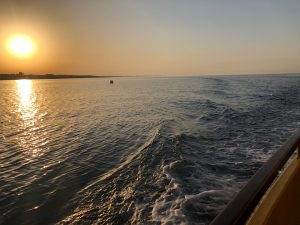
Here is a puzzle for you.

Walking along a beach, first, the waves looked like this: One wave breaking at a time.

That’s the situation you also see in the foreground of the picture below, while in the background, a little further down the beach, something else starts happening.

If we look closely at that situation (shown in the picture below), there are several waves breaking at the same time, one behind the other.

And it isn’t just coincidence, it keeps happening throughout hundreds of pictures I took that windy Sunday. Why is that?

I think (and this theory would be easy enough to test if the water was warmer or if I wasn’t such a sissy) that the slope of the beach is just different on either side of this little jetty or whatever it is. The shallower the slope, the earlier waves of the same wavelength can “feel” the sea floor, or the shorter waves have to be to “feel” the sea floor at the same distance from the water line.

So I think the slope on the left of the jetty is shallower than on the right, making the incoming wave field that is the same on either side (I’m assuming, but give me a good reason for why it shouldn’t be?) behave differently.

Funnily enough, the only reason I ended up on that beach was that I wanted to go watch a cruise ship go through the locks and into the Kiel canal with a friend. And, funnily enough, the ship decided to not go through the Kiel canal, as it did the week before. So we decided that we should go to the beach. Very good decision! :-)

But here is a “before” pic from when I was still thinking I would be writing a blog post about the ship going through the locks. Isn’t the seagull hilarious, posing like that?

Wave watching: Refraction and diffraction of waves

A little more wave watching, today with a focus on how waves change direction when they run into shallow water. Let’s look at this beautiful wave and see what happens when it reaches the shallow shore.

Above, you see the wake of the pilot ship, consisting of many wavelets that propagate as parallel wave crests towards the shore.

Below, you see that the wave is propagating at an angle to the shore (something around 45 degrees, maybe?). If you focus on the wave crest that is just offshore of that little obstacle in the water (curious enough, a piece of brick wall), you clearly observe that angle. But then looking at the next wave crest in-shore, it is almost parallel to the shore! Assuming that both crests come from the same wave field, so that the second one was in the same position as the other one only moments before (which I know it was because I observed it), something clearly happened between then and now.

Refraction of waves

Why do waves change direction as the water depth changes? As waves run from deep into shallow water, at some point they start to “feel” the bottom, which slows them down.

Or, more scientifically speaking, the dispersion relation for shallow water waves is a function of water depth: The shallower the water, the slower the waves. That means that if a wave crest is running on a slope with one side being in shallower water while the other one is still in deeper water, it will change direction towards the shallow water because the shallow side of the crest is slowed down while the deeper side keeps on moving faster, thus forcing the whole crest around a curve.

But in this picture series there is more to see: See how the wave crest gets deformed after it has passed that obstacle?

Diffraction of waves

This is a process called diffraction: The change of direction after a wave crest has passed either through a slit and then starts radiating from that slit as circle segments, or, in this case, an obstacle. The wave passing an obstacle is, in a way, the same as the wave passing through two wide slits which are very close to each other, only separated by the obstacle: The edges of the wave crest at the edges of the “slits” also start radiating out as circle segments!

One spot, so many things to observe!

And there are, of course, ships. What I wanted to show on this picture is a close-up of the turbulent wake of the ship, but it’s really difficult to see so I’ll let that pass for today.

And the picture below shows so much cool stuff: Waves radiating from that pylon. Ripples on the surface by a gust of wind. Wave crests getting a lot steeper as they run up on the slope. And, my main reason for posting: I really like how the wave is spilling as it breaks! :-)

Waves break when they reach a critical steepness

You can quite accurately predict when a wave is going to break. When it will break depends on its steepness, which depends on the slope that it is running up on. So due to the funny beach shape caused by the differential erosion on the upstream and downstream sides of groynes we can watch one and the same wave crest break several meters apart depending on the side of the groyne we look at. Kept me fascinated for the better part of the three days we spent in Hastings, and would have kept me entertained for a lot longer, I am sure, had I not had to go to a conference (and win a poster award there, so it was all worth it in the end ;-))

Here we see a wave breaking on the right side of the groyne, while at the left side the previous wave is still breaking and the one breaking on the right side hasn’t even developed a clear crest yet:

IMG_5760

It’s a lot easier to see in a movie. Have fun!

Types of breaking waves depending on steepness of slope – small scale

Video of different types of breakers – small scale.

In this recent post we talked about types of breakers depending on the steepness of the slope. But even on a single stretch of coast line you can easily observe several kinds of breakers. My friend E lend her cabin on an island just outside of Bergen to me and another friend E for the weekend, and just sitting on the rocks we could observe at least two types of breakers.

Different types of “breakers” depending on the slope of the beach. Also see video below where it might become more clear…

In the movie below, you see surging breakers on the first little headland – the water level just raises and falls and no breaking occurs – whereas in the small bay behind the headland and on the next headland the slope is much less steep and here spilling breakers develop. Spilling breakers can also be seen about halfway through the movie on the right hand side beach. Isn’t it awesome how you can see so many concepts on the smallest scales once you start looking for them?

Waves breaking depending on steepness of the slope

Waves breaking on slopes of different steepnesses.

Depending on a slope’s steepness, waves can break in very different ways. On nearly horizontal beaches, spilling breakers develop. On steeper beaches, plunging breakers, the kind of breakers that form the tunnels that people surf in, form. And on very steep beaches, the breakers don’t actually break, but surge up and down.

Types of breakers developing on beaches depending on the beach’s slope.

This can be seen on  the large scale when different beaches are known for different kinds of breakers, and one impressive example are Oahu’s North Shore plunging breakers that my friend Tobi took me and a couple of friends to see in 2010.

Plunging breakers on Oahu’s North Shore in September 2010.


DSCF0384

Another plunging breaker on Oahu’s North Shore. See surfer for scale.

More awesome breakers were to be seen on the Big Island a couple of days later:

Plunging breakers on Big Island in September 2010.

And of course I have movies of those breakers for you, too, first Oahu and then Big Island:


Internal waves in the atmosphere

A photo of internal waves in the atmosphere.

Internal waves exist on the interface between fluids of different densities. In the ocean they are mostly observed through their surface imprint. In the tank, we could also observe them by looking in from the side, but this is hardly feasible in the ocean. But luckily vision is easier in the atmosphere than in the ocean.

On our research cruise on the RRS James Clark Ross in August 2012, we were lucky enough to observe atmospheric internal waves, and even breaking ones (see image above). This is quite a rare sight, and a very spectacular one, especially since, due to the low density contrast between the two layers, the waves break extremely slowly.

It is really hard to imagine what it looked like for real. This movie shows the view of Jan Mayen – the volcano, the rest of the island and then the atmospheric waves. Please excuse the wobbly camera – we were after all on a ship and I was too excited to stabilize properly.