Tag Archives: clouds

April weather in September (Great for #WaveWatching and cloud watching!)

Minutes after drawing the illustration to the “you are not a drop in the ocean, you are the ocean in a drop” quote I shared yesterday in the most beautiful sunshine, the sky started looking like this.

Luckily I had a nice spot from which I could observe what happened next…

…lots of drops. In the ocean. Or oceans in the drops? Who knows. Anyway, after just having done that drop drawing, I couldn’t very well get upset, and I love watching rain on water anyway.

Just look at all the wave rings, and the way drops are catapulted up again only through surface tension!

Here is a (first normal speed, then slow motion) video so you can appreciate it properly, too:

As the rain passed, I found it super impressive to watch the rain showers as they went down elsewhere.

Like over the mouth of Kiel fjord, and I am showing the same spot repeatedly in the following (with more or less the same view, you can use the buoy as point of reference).

I don’t know enough about meteorology to understand what’s going on there, but I can still appreciate the beauty of the rain cloud and how differently things look where it is propagating to (to the right) and where it has already left (to the left).

See how much lower the clouds on the right are, and clearly a different kind of cloud compared to the ones on the left?

At times, it got really dark.

And I watched this one cloud move, continuously raining.

Then there was a dry period of a couple of hours, and when I walked home, it looked like this: Again distinct areas with rain showers.

What I found also really interesting is the swimmer’s wake you see below. There is so much to see in that one picture: The wake, the rain shower in the background, the changing surface roughness from rougher, darker areas, and smoother, lighter areas, and then the areas in the foreground where we can look into the water (see here for why we can do that in some places and not in others)

Same thing as above, only in a different picture…

And again, this time with a really impressive black cloud. And interference pattern in the waves in the foreground.

And now even ring waves that that seagull made…

And as if I hadn’t had enough wave watching in one day, here is a different spot in the afternoon. See the interference pattern as waves get refracted around the bollard?

And, of course, another strong shower came and made us retreat to the inside. But see the rainbow in the picture below? Those are the kind of things that make me really happy! :-)

Atmospheric & water wave watching

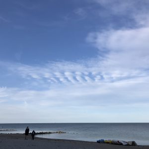
What I find really fascinating about watching waves in the atmosphere rather than on water is that all the waves that become visible are not surface waves like on water, but internal waves. Which we have to go to great lengths to make visible in water (for example by adding dyes in tank experiments) but which we can’t just visually observe in the sea in the same way as we can in a transparent atmosphere.

In the atmosphere, however, we also don’t see every internal wave going on, either, we need very specific conditions for them to become visible. So whenever I see one, I start pondering why we see exactly what we see, why there are clouds in some places and not in others. Below, for example, we see the troughs of an internal waves in cloud stripes, but the crests don’t form clouds. Fascinating how just displacing air by a little bit can cause clouds to form and to disappear!

And things become super cool when you combine atmospheric wave watching with “normal” wave watching like in the picture above. There you see the rough surface with tiny little wind waves in the background, waves coming around the break water, the calm water in the lee of the break water, sheltered from the wind, and then the reflection of the atmospheric waves on the water.

And you thought it couldn’t get any better? Well, you were wrong! Now there are also some waves on the water, plus soap bubbles! :-)

Now, for a thought experiment: What would soap do to the waves? Would destroying surface tension actually matter? I think not in this case, or t least not close to land in the picture above, since the waves are mainly gravity waves, not capillary waves. But what do you think?

#wavewatching in the sky

On Elin’s student cruise (read more about that here) very nice wave watching was to be had, both on the water as well as in the sky.

In the picture below, if you look slightly left of the mountain top in the right of the picture, you see five parallel cloud stripes — evidence of the air moving in a wave motion after going over that mountain top! This motion results in clouds being there for certain phases of the waves and then no clouds for others, and since the movement is periodic, this results in cloud stripes. Now if I knew more about cloud formation I could probably tell you what changes with height except for pressure, and how that results in cloud formation or no cloud formation, and hence whether the cloud stripes indicate wave crests or wave troughs. My gut says troughs. Does anyone know?

Another very nice wave pattern is seen below: Kelvin-Helmholz instabilities! Those are shear instabilities that will eventually start breaking. Unfortunately I went back to work and next time I looked I didn’t find them again.

Cloud in a bottle experiment

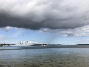
Guest post by Susann Tegtmeier (written two months ago, I just never got around to posting it. Sorry!)

No one likes clouds when they bring rain, but what if you could make your own? Making a cloud inside a bottle will help us to understand how they are formed in the atmosphere. The experiment demonstrates how changes in air pressure, temperature and volume are related and how these changes can lead to the sudden appearance of tiny water droplets, or in other words, lead to the formation of a cloud.

You can do the experiment alone at home, in front of a classroom or as a hands-on experiment with all your students. I have chosen the latter option as part of my ‘Introduction to meteorology’ lecture for the first-year students in the Bachelor program ‘Physics of the Earth System’. For this class, Mirjam and I received funding from our university’s PerLe project for teaching innovations. We use the PerLe funding to consolidate the student’s physical-based understanding of the climate system through various experiments, exercises and discussions.

For the experiment you need an air-tight, transparent container that you can pump up with air (in order to increase the pressure inside the bottle). We made a simple version using materials from home including a plastic water bottle supplemented with valve from a bike tire that is attached between the bottle and the cap. Furthermore you need a pump (in our case a bike pump), water and matches.

Picture by Susann Tegtmeier

During the first round of the experiment, the students pumped up the bottles enhancing the pressure inside. During our discussion before the experiment, the students assumed correctly that the bottles would warm due to the enhanced pressure under a constant volume. By putting their hands around the bottles, it was possible for the students to feel that indeed the air inside the bottles was warming. When opening the valve slowly the opposite effect could be noticed and the bottles cooled very quickly. While the temperature change is small, it turned out to be quite fascinating and memorable for the students to see and feel the ideal gas law, they learned about earlier in class, in real life action.

During the second round of the experiment, the pumping up of the bottles was repeated, but this time with a small amount of water in the bottles. Since warm air can take up more water vapor than cold air, some of the water in the bottle was evaporated during the increase of pressure and temperature. While we discussed this effect during the experiment, it was, of course, not possible to observe the formation of the invisible water vapor. The next step of the experiment, the opening of the valve and the accompanying cooling of air, can theoretically lead to the condensation of the above discussed water vapor back to water. However, to the surprise of the students, no condensing little water droplets could be seen in the bottles.

Picture by Susann Tegtmeier

In order to lift the mystery, we carried out the third part of the experiment. With the bottle open, we lit a match and a moment later threw the blown out, smoking match into the bottle. Now the bottle needs be closed quickly before the same action (pumping of bottles and opening of valve) can be repeated. Only in this last round of the experiment, the expected water droplets became visible while the air was cooling. The reason is that small condensation nuclei are necessary for water vapor to condense and form water droplets. The experiment demonstrates this effect quite nicely in the bottle, but it also holds on large scales for the formation of atmospheric clouds.

The ‘Cloud in a bottle’ experiment is a perfect class room exercise, as it leads the students within 30 min from the basic, physical principles of the ideal gas law to one of the big climate effects, the aerosol – cloud interaction.

Waves in the clouds

On my way back from London I had an almost equally interesting flight as on my way to London, which I talked about here and here. Except that most of the excitement this time round came from discovering that I wasn’t, in fact, sitting next to the person I thought I was, but that I was booked on a different flight from a different terminal. Which isn’t so terribly exciting in itself, but seeing that Terminal 5 is quite a distance away from the other terminals and the discovery itself happened at security some 20 minutes before boarding was supposed to start, it made for an interesting race across Heathrow.

But at least I ended up seeing pretty waves in the clouds:

IMG_5857

Cloud waves – wave clouds

Another one of those days where I kinda wish I had taken at least some meteorology at some point (only “kind of” because I wouldn’t want to miss any of the stuff I actually took…). But on my way to work I saw the clouds below:

IMG_1821

The internet says they might be cirrocumulus undulatus clouds.

IMG_1829

In any case, the wavy clouds started to disintegrate into cirrocumulus-like clouds.IMG_1822

But whatever they were, they were very pretty!
IMG_1837Meteorologists out there (Torge! :-)) – what kind of clouds were they and why did they form?


Internal waves in the atmosphere

A photo of internal waves in the atmosphere.

Internal waves exist on the interface between fluids of different densities. In the ocean they are mostly observed through their surface imprint. In the tank, we could also observe them by looking in from the side, but this is hardly feasible in the ocean. But luckily vision is easier in the atmosphere than in the ocean.

On our research cruise on the RRS James Clark Ross in August 2012, we were lucky enough to observe atmospheric internal waves, and even breaking ones (see image above). This is quite a rare sight, and a very spectacular one, especially since, due to the low density contrast between the two layers, the waves break extremely slowly.

It is really hard to imagine what it looked like for real. This movie shows the view of Jan Mayen – the volcano, the rest of the island and then the atmospheric waves. Please excuse the wobbly camera – we were after all on a ship and I was too excited to stabilize properly.